
For decades, southwestern Finland occupied an awkward position in reconstructions of Viking-Age trade. The region sat beside major sea routes linking Scandinavia with the eastern Baltic and river systems leading toward Russia, yet comparatively little archaeological evidence seemed to show sustained commercial activity on the Finnish mainland.
A study published on August 19, 2026 changes that picture.
University of Helsinki researcher Yann Irissou analyzed 481 Viking-Age trade-related finds from southwestern Finland, including silver, weights and weighing equipment. Most strikingly, 368 of those finds were registered within the previous ten years.
Their distribution suggests that southwestern Finland was not simply a peripheral landscape passed by Scandinavian traders. Communities there appear to have participated directly in the Baltic silver economy through river valleys, coastal routes and local trading centers.
The strongest candidate is Pappila in Nousiainen, where a concentration of weights, coins and other finds resembles material from Finland’s only previously confirmed Viking-Age trading site.
481 Finds Create A Very Different Archaeological Map
Irissou’s study, published in the Journal of Maritime Archaeology, brings together evidence recorded through excavations, surveys and metal detecting up to 2025.
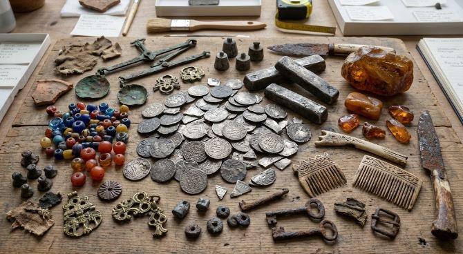
The Viking Age trade study catalogs:
- 287 silver coins, silver rods and pieces of hacksilver
- 172 weights
- 14 weighing scales
- 5 sprue stalks
- 3 weighing-scale containers
Together, those 481 objects provide a much larger dataset than archaeologists had available only a decade ago.
In 2013, just 109 relevant finds were known. By 2025, that number had reached 481.
The increase partly reflects the rapid growth of recreational metal detecting in Finland. New reporting guidelines introduced in 2015 and the creation of the Metal Detectorists of Finland Proper association in 2016 contributed to more finds entering archaeological records.
That creates an important limitation. Metal detectorists do not search every landscape equally, and accessible agricultural fields receive more attention than many forests or less accessible areas.
Even with that bias, the distribution is difficult to explain as random loss.
Irissou found that 462 of the 481 objects — about 96 percent — lay within one kilometer of known Iron Age sites.
The pattern points toward trade taking place inside settled landscapes rather than only at isolated coastal stopping points.
Finland Was Already Sitting Beside A Major Viking Route
Southwestern Finland occupies the northeastern edge of the Baltic Sea beside the Archipelago Sea.
During the Viking Age, roughly AD 800–1050, this area lay along the Austrvegr, or eastern route. Scandinavian travelers could move east through the Baltic and into the river systems of what are now Russia and Ukraine, eventually connecting with markets much farther south and east.
That geographical position has never been in doubt.
The puzzle was why archaeological evidence for organized trade in Finland appeared so limited.
Until now, Kyrksundet on Hiittinen Island has been the central site in that discussion. Discovered in 1991, Kyrksundet remains the only firmly established Viking-Age trading site in Finland. Excavations and metal detecting there have produced evidence of seasonal trading and workshop activity, including 31 silver coins.
Its location was significant. Kyrksundet stood along the maritime route rather than inside one of southwestern Finland’s settled mainland river valleys.
That encouraged an older interpretation in which Finnish communities participated in long-distance exchange only indirectly or sporadically.
The new dataset challenges that model.
Instead of a single trading point facing outward toward the Baltic, Irissou identified clusters of commercial material deep within landscapes occupied by local communities.
Pappila May Be Finland’s Missing Mainland Trading Site
The most intriguing concentration occurs at Pappila in Nousiainen.
Twenty-eight trade-related objects form a cluster around a small stream flowing toward the Hirvijoki River. Around 400 meters to the east stand Nousiainen’s medieval church and the Pyykoski rapids.
During the Viking Age, the river system was accessible from the sea.
The site’s archaeological character is broader than a handful of coins. Metal detecting has produced equal-armed, ringed and convex penannular brooches, belt fittings, a small bell and an earspoon. Bronze slag and sheet metal suggest possible craft or workshop activity.
The trade assemblage includes weights, western silver coins and Samanid dirhams.
One coin is a penny of Henry II dated AD 1002–1024. Another fragmented western penny belongs roughly to the late ninth or early tenth century. One identified Samanid dirham dates to the reign of Mansur ibn Nuh I, AD 961–976.
Irissou compared Pappila’s assemblage statistically with Kyrksundet.
The similarity score was 0.84, where a score of 1 would represent identical assemblage composition.
That does not prove Pappila was a marketplace. Excavation would be needed to establish the site’s precise function.
It does make Pappila one of the strongest candidates yet found for a previously unrecognized Viking-Age trading center on Finland’s mainland.
Rivers May Explain How The Network Worked
One of the clearest patterns in the dataset involves waterways.
Finds cluster along river valleys such as Nousiainen, Masku, Sauvo, Halikko and Paimio, often near points where boats moving inland would encounter rapids or other obstacles.
These locations could have served as natural transfer points.
Goods moving by sea might be unloaded, carried around rapids or transferred into smaller river craft. Local products could move in the opposite direction toward the Baltic.
In Nousiainen alone, 85 trade finds were recorded within roughly 1.5 kilometers of the church and Pyykoski rapids. That represents nearly 18 percent of the entire 481-object dataset.
The concentrations often weaken beyond the first major rapids.
Irissou interprets that pattern as evidence for a connected maritime and river-based system linking coastal trade with inland production areas.
Such a network could have carried furs, bone products and other resources toward Baltic markets.
The 481-find research dataset has been made publicly available, giving other researchers an opportunity to compare the distribution with environmental, settlement and economic evidence.
Silver Shows That Local Communities Knew The Same Trading System
Silver is particularly important to this interpretation.
Viking-Age Baltic commerce often relied on bullion rather than coins with fixed face values. Silver could be weighed, cut and exchanged according to mass.
That explains why archaeologists pay close attention to hacksilver, scales and standardized weights.
The southwestern Finnish finds show all three.
Their distribution suggests that people living in these river valleys were familiar with a system used across much of the Viking trading sphere.
The silver itself came from several directions.
Eastern Islamic dirhams demonstrate connections with the vast silver flows moving through eastern Europe, while western European coins indicate contact with expanding western monetary systems.
Pappila contained examples of both.
That mixed material matters more than simply finding an imported object. A foreign brooch could travel through gift exchange, migration or several intermediate owners. Weights, scales and chopped silver together provide stronger evidence for transactions.
The study argues that these communities were participating in the same silver-and-weight economy used elsewhere around the Baltic.
Birka Helps Explain Finland’s Wider Connections
The Finnish evidence does not stand alone.
Material from Birka in Sweden has already shown connections with western and southwestern Finland. Finnish objects have appeared in elite graves there alongside scales, weights and other evidence associated with commerce.
Irissou suggests that traders operating from southwestern Finnish centers could have maintained seasonal connections with Birka, the Estonian center at Iru and other Baltic nodes.
That does not require imagining merchants from every Finnish settlement sailing across the entire Viking world.
A regional network could move resources gradually from inland areas toward river centers, then toward maritime hubs and larger international markets.
This fits the broader picture emerging from Viking archaeology: major trading towns depended on networks of smaller communities that supplied resources, handled redistribution and connected inland economies with the sea.
For another Old Norse News example of how a small archaeological object can alter interpretations of Viking society and religion.
The Finnish evidence applies the same principle on a much larger scale. Hundreds of individually modest finds become historically important once their locations are mapped together.
The Finds Do Not Make Every Site A Marketplace
The study still requires caution.
Many objects were recovered from ploughed fields rather than controlled excavations. That means their original archaeological contexts are often missing.
Some clusters can also produce misleading signals.
For example, concentrations at Taskula and Kirkkomäki initially resembled possible trade centers statistically. Archaeological work showed that both were burial grounds, where deposited objects created unusually dense find patterns.
Pappila and Jokipelto in Raisio remain more promising.
Jokipelto produced a cluster of 16 trade-related finds near a Late Iron Age settlement, workshop evidence and an excavated burial ground that may have included an eighth-century boat burial. Yet reaching this part of the Raisio River from the sea would apparently have required portage or transshipment around rapids.
Those uncertainties are useful rather than inconvenient. They show why spatial analysis can identify locations worth investigating without turning every concentration into a confirmed Viking marketplace.
Finland Looks Less Peripheral Than It Did Before
The 481 finds change the debate because they reveal structure.
Silver and weighing equipment cluster near waterways. Many finds lie near settlement centers. Concentrations often appear around natural transport bottlenecks, and Pappila produces a material signature unusually similar to Kyrksundet.
That pattern suggests southwestern Finland was connected to Baltic trade through its own internal network rather than merely receiving occasional imported objects from Scandinavian visitors.
The region’s communities appear to have understood silver exchange, maintained routes between inland and coastal areas, and participated in commercial connections extending toward Birka, Estonia and the eastern Baltic.
Future excavation at Pappila could strengthen or weaken the trading-site interpretation.
For now, the larger change is already visible.
Finland no longer looks like an empty margin beside the Viking trade routes. The combination of coins, hacksilver, scales, weights and waterways instead points toward communities operating inside the Baltic economic system itself.
