
Roskilde’s Sankt Clara Monastery never disappeared completely from history. Medieval records preserved its name and location, and historians knew that a community of nuns occupied the site from the 13th century. The buildings themselves posed the greater mystery. After the Reformation brought the monastery’s religious life to an end, builders dismantled so much of the complex that archaeologists had little reason to expect substantial architecture beneath the ground.
That picture changed in August 2026.
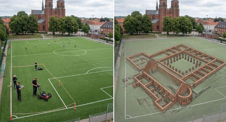
Ground-penetrating radar beneath the sports field at Byparken detected an extensive monastery complex roughly one metre below the modern grass. Researchers identified four wings around a cloister courtyard, internal rooms, pillar foundations, covered passages and a church in the southern wing. The northern and eastern ranges produced some of the clearest signals.
The discovery carries significance far beyond the survival of medieval walls. Sankt Clara now gives archaeologists a chance to reconstruct one of Roskilde’s female religious communities, redraw part of the medieval city and address a modern planning question involving archaeological remains and proposed construction.
Sankt Clara Was Lost Architecturally, Not Historically
Calling Sankt Clara a “lost monastery” can create the wrong impression. Archaeologists did not discover an unknown religious house beneath a sports field. Historical sources had already placed the monastery at Byparken.
Researchers simply did not know how much architecture remained.
ROMU, the museum organization that includes Roskilde Museum, announced the new results on August 11, 2026. The investigation grew from Roskilde Municipality’s consideration of an underground parking facility beneath the sports area. Since medieval records located a nunnery there, ROMU arranged a non-destructive georadar survey before construction could disturb the ground.
The scans produced far more detail than researchers expected.
According to ROMU’s Sankt Clara georadar results, masonry and other structural features survive about one metre beneath the surface. Archaeologist Jesper Langkilde explained that researchers already knew the monastery had occupied the location, but they had not known how much survived from the complex founded in 1256.
That difference changes the archaeological value of the site.
Documents can identify where an institution once stood. Preserved architecture can show how its inhabitants organized space, moved through buildings and positioned their community within a town.
Sankt Clara now offers both kinds of evidence.
Four Monastery Wings Restore A Missing Piece Of Roskilde’s Map
Georadar results show the monastery’s organization with unusual clarity.
NIKU building archaeologist and monastery specialist Regin Meyer identified four wings arranged at right angles around a cloister courtyard. Researchers detected several room divisions, foundations linked to structural pillars, characteristic cloister passages and possible additional buildings outside the central quadrangle.
A church occupied the southern wing.
Signals from the eastern range reveal especially detailed remains. Researchers can distinguish internal divisions and features that may represent foundations for vaulting pillars. The northern range appears similarly clear in the processed radar data.
Such detail matters in Roskilde because centuries of construction have erased or obscured parts of the medieval town. Historians know that monasteries occupied a significant place in its physical and social organization, but researchers still lack complete plans for many parts of the city.
Sankt Clara ranked among Roskilde’s five known medieval monasteries. ROMU describes it as the last of those five institutions whose surviving archaeological form remained uncertain.
The new survey changes that situation.
Researchers no longer have to place an approximate monastery symbol on a historical map. They can discuss the orientation of individual ranges, the position of the church, movement around the cloister and possible structures beyond the main complex.
Ground-penetrating radar still has limits. It cannot identify the exact purpose of every room or establish detailed dates for each construction phase. Archaeologists need physical investigation when they want to determine materials, chronology and relationships between deposits.
The technology does something different exceptionally well: it supplies a detailed plan before excavation begins.
NIKU archaeologist Arne Abel Stamnes described the results as among the clearest he has documented from a Scandinavian monastery with georadar. NIKU’s Sankt Clara survey account reports that the archaeological features appeared clearly enough for the team to recognize major structures during the survey work.
That represents a striking reversal for a monastery long thought to have suffered near-total destruction.
The Year 1256 Connects The Ruins To A Specific Religious Community
Sankt Clara belongs to Roskilde’s high medieval history rather than the Viking Age. Its foundation still forms part of the broader transformation that turned Scandinavian political and trading centres into cities increasingly shaped by formal Christian institutions.
The monastery housed Poor Clares, members of the female branch of the Franciscan movement.
Historical research connected with ROMU has traced its foundation closely. Ingerd of Regenstein, an aristocratic woman who controlled substantial Danish property, played a central role in establishing the house. Planning appears to have started during the early 1250s, and Ingerd’s testament of August 1, 1256 securely documents the monastery.
Her property endowment supplied an important economic base for the new community.
That documentary history increases the value of the radar map. Archaeologists can connect these buried structures with a named institution, an identifiable patronage network and a community of medieval women rather than treating them as an anonymous collection of foundations.
Sankt Clara left another valuable historical resource: written records. ROMU research has highlighted medieval archives connected with Sankt Clara and Vor Frue in Roskilde that preserve original papal letters from the 13th and 14th centuries.
Researchers can now place documents and architecture beside each other.
Written sources may record property, patronage, privileges and disputes. Archaeology can provide evidence for the physical spaces where the community worshipped, worked, ate and organized daily life.
That combination gives Sankt Clara particular research potential. Archaeologists have had fewer opportunities to investigate female monastic houses than many male religious institutions.
Langkilde has pointed to the rarity of archaeological investigations of nunneries in Roskilde and Denmark. Carefully targeted future trenches could reveal evidence involving architecture, food, objects, craft activities and everyday organization within the community.
The Sports Field Protected What Demolition Left Behind
The survival of Sankt Clara may owe something to a simple circumstance: later generations kept much of the site relatively open.
The monastery suffered extensive dismantling after the Reformation. ROMU and NIKU report that people sold approximately half a million bricks from the complex for construction at Selsø Castle. Loss on that scale encouraged the assumption that little useful archaeology remained.
Removing walls, though, does not necessarily erase an entire building.
Foundations can remain underground after builders carry away reusable masonry. Floor levels, pillar bases, drainage features and lower wall courses may survive too. Deep modern construction often causes more archaeological damage than historic stone or brick robbing.
Byparken followed a different path.
A sports field covered the area rather than dense buildings with cellars, deep foundations and utility networks. Recreational use allowed buried features to survive beneath grass and soil.
Modern land use unintentionally protected a medieval archaeological site.
The same principle appears elsewhere in Scandinavian archaeology. Familiar landscapes can preserve earlier settlements directly beneath apparently ordinary surfaces. Around Hamar, research into the Valum cemetery and Christian transition has similarly shown how archaeological evidence can sharpen broader questions about the shift from Viking-period practices into medieval Christian society.
Roskilde offers the same lesson at an architectural scale.
A modern sports field now covers a readable medieval monastery.
Its archaeological importance comes less from the visual contrast between football and monastic life than from the unusual survival of the structures beneath it.
Roskilde’s Five Monasteries Shaped The Medieval City
Sankt Clara becomes more informative when researchers place it back within medieval Roskilde.
Royal authority, church institutions, commerce and regional transport all influenced the town. Roskilde Cathedral dominates the surviving medieval skyline, but religious life extended well beyond the cathedral precinct.
Five monasteries formed part of the city.
These institutions controlled land, received donations, housed religious communities and maintained connections far beyond Roskilde. Their churches, courtyards, gardens, service buildings and boundaries occupied significant amounts of urban space.
Sankt Clara’s reconstructed plan can restore part of that missing institutional geography.
Its Byparken location places the convent within Roskilde’s wider urban structure rather than at an isolated religious site. Future work on boundaries and buildings beyond the central quadrangle could show how the monastery related to roads, neighbouring properties and other parts of town.
That evidence may change how historians visualize medieval Roskilde.
Maps that concentrate on royal buildings and major churches can make kings and bishops appear to dominate almost every part of city life. Monasteries complicate that picture. Separate religious communities controlled property, managed resources and occupied distinct areas inside the town.
A female monastery adds another important layer.
The georadar survey cannot assign a function to every room. Archaeologists will need targeted excavation before they can securely date construction phases and interpret individual spaces.
Yet the newly mapped four-wing plan gives any future excavation an unusually precise starting point.
Georadar Lets Archaeologists Target Questions Before Digging
The Sankt Clara project shows how geophysical archaeology can change research and heritage management.
Ground-penetrating radar sends electromagnetic signals through the soil. Different buried materials reflect those signals in different ways, allowing specialists to identify patterns that can correspond with walls, floors, foundations and other archaeological structures.
Researchers can examine those patterns without first removing the soil.
At Sankt Clara, that method has already located probable major walls, cloisters, rooms and pillar foundations. Archaeologists can use the resulting map to position future trenches around particular research questions rather than opening broad areas without knowing where significant structures lie.
This approach can protect archaeology as much as investigate it.
Denmark’s Agency for Culture and Palaces explains in its archaeological heritage guidance that Danish heritage management gives strong consideration to preserving archaeological remains in place. When development threatens important remains, planners may alter projects or archaeologists may need to investigate affected areas first.
Sankt Clara now presents exactly that problem.
Georadar revealed the monastery without damaging it. The resulting map may allow planners to identify which areas a development could avoid and which sections require closer archaeological investigation.
Researchers can gain information without automatically excavating every wall they locate.
That distinction matters because excavation itself permanently changes an archaeological site.
The Parking Proposal Turns The Discovery Into A Modern Planning Question
The discovery has immediate practical significance since plans for an underground parking facility helped trigger the investigation.
Sankt Clara differs from Roskilde’s four other known medieval monasteries in an important heritage-management respect. ROMU reported in August 2026 that the other monastery sites have ancient-monument protection, whereas Sankt Clara lacked comparable status partly because experts had assumed that demolition destroyed most of it.
Georadar now challenges that assumption.
ROMU has entered discussions with Roskilde Municipality and the Agency for Culture and Palaces about the site. Museum officials have identified trial excavation as a possible next step within sections that proposed construction could affect.
Such trenches could establish the condition, date and archaeological value of particular remains before officials make further planning decisions.
ROMU has expressed interest in keeping the best-preserved areas outside the construction footprint, allowing those sections to remain underground.
That choice illustrates a central issue in modern archaeology.
Public attention often focuses on excavating spectacular ruins. Heritage professionals frequently prefer to preserve significant archaeology where it lies when researchers can answer necessary questions without removing it.
Sankt Clara makes the choice especially visible.
For centuries, the sports field protected the monastery. An underground construction project could reach the same depth as its surviving walls.
Roskilde’s medieval archaeological map has now become part of its modern planning map.
Sankt Clara Could Bring Medieval Roskilde’s Women Into Sharper Focus
The surviving architecture carries clear importance, but the identity of the community gives the site another layer of value.
How did the women of Sankt Clara live from day to day?
Historical documents can identify founders, properties, donations and legal transactions. Such sources rarely record all the routines that shaped daily life inside a religious house.
Archaeological deposits could fill parts of that gap.
Animal bones, seeds and other food remains could reveal aspects of diet. Ceramics and metal objects might provide evidence for consumption and household activities. Changes to buildings could show how the monastery reorganized its spaces over generations.
Researchers may find equally valuable evidence outside the main ranges.
A medieval convent needed areas for worship, residence, cooking, storage, administration and practical work. Gardens, wells, drains, service buildings and boundaries may have occupied ground beyond the central cloister.
Meyer has already identified possible structures outside the monastery’s main quadrangle in the radar results.
Those features could tell researchers as much about daily life as the church does.
A church establishes the religious identity of the institution. Kitchens, service buildings, drainage and working areas can reveal how its inhabitants made that institution function.
Sankt Clara could consequently become more than an architectural discovery. Careful research may restore parts of the lived experience of women who occupied one of medieval Roskilde’s major religious communities.
Why A Monastery Under Grass Changes Roskilde’s Medieval Story
Sankt Clara matters because the georadar survey returned physical form to an institution that historians had known largely through documents and historical memory.
Researchers can now map the monastery founded in 1256 as an actual architectural complex.
Four ranges surrounded a cloister courtyard. The church occupied the southern wing. Rooms and structural supports remain visible beneath the eastern and northern ranges. Possible additional structures extend beyond the central enclosure, and much of this archaeology sits only about one metre beneath a modern sports field.
These results strengthen the image of medieval Roskilde as a city shaped by numerous religious institutions rather than simply a royal settlement dominated by its cathedral.
Sankt Clara may give archaeologists a rare opportunity to investigate a medieval female religious community. Its unusually clear georadar plan can guide any future excavation with much greater precision. The discovery has also forced modern planners to consider how proposed underground construction should interact with a newly mapped archaeological monument.
Most importantly, Sankt Clara shows why historians should distinguish between a demolished building and an archaeologically lost one.
People could remove hundreds of thousands of bricks without destroying every foundation beneath the soil. Centuries later, georadar has reconstructed enough of the monastery’s footprint to restore it to Roskilde’s medieval map.
Byparken can no longer represent empty space in that reconstruction.
Under the grass lies evidence capable of changing how researchers study Roskilde’s religious geography, the role of women within its medieval institutions and the survival of archaeological structures beneath spaces that modern residents use every day.
