
The circular rampart at Fyrkat usually dominates photographs of Harald Bluetooth’s fortress near Hobro. Yet the 16 longhouses that once filled the enclosure may tell an even more revealing story about what the Danish king tried to accomplish around AD 980.
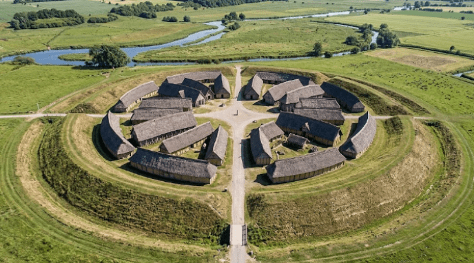
Archaeologists reconstructed Fyrkat as a highly ordered compound rather than a settlement that grew house by house. Four gates faced the cardinal directions. Two timber-paved roads crossed at the centre. Inside the four resulting quadrants stood four nearly identical longhouses arranged around a square courtyard—16 buildings planned as part of one architectural system.
Each longhouse measured about 28.5 metres in length and roughly 7.3 metres across at its widest point. The fortress itself had an inner diameter of approximately 120 metres. Its rampart measured about 12 metres across, and a V-shaped ditch roughly 7.5 metres wide and 2 metres deep strengthened the perimeter.
That precision matters.
Fyrkat was not simply a defensive circle with houses squeezed inside it. The housing belonged to the same standardized concept as the gates, roads, rampart, and geometry. UNESCO now treats Fyrkat, Aggersborg, Trelleborg, Nonnebakken, and Borgring as one integrated system of late-10th-century royal construction associated with Harald Bluetooth.
The 16 longhouses therefore offer a way to ask a larger question: was Harald building forts, or was he experimenting with an entirely new way to organize people, resources, movement, and royal authority?
The 16 Longhouses Were Part Of The Fortress Plan From The Start
Fyrkat’s longhouses make most sense when viewed from above.
Two roads crossed at right angles through the middle of the fortress, dividing the circular interior into four quadrants. Each quadrant contained one block of four longhouses arranged as four sides around an open courtyard.
The resulting plan looks strikingly controlled.
UNESCO’s Viking-Age Ring Fortresses documentation identifies this strict geometry as one of the defining characteristics of Harald Bluetooth’s fortress system. Fyrkat shared its basic planning principles with other ring fortresses constructed between about AD 970 and 980.
At Fyrkat, every group repeated the same architectural idea.
The longhouses were approximately 28.5 metres long, about 7.3 metres wide at the centre, and narrower at the straight gables. Each building contained a large central hall with smaller rooms toward the ends.
Archaeologists have excavated three of the four longhouse blocks. The fourth remains largely untouched.
The Viking Ship Museum notes in its Fyrkat archaeological overview that leaving part of the fortress unexcavated preserves archaeological material for future researchers with methods that may reveal evidence earlier excavations could not recover.
That unfinished archaeological record matters.
Fyrkat’s plan already looks extraordinarily regular, but one quadrant still has the potential to refine how researchers interpret life inside the enclosure.
Standardized Houses Suggest Standardized Expectations
Most Viking-Age farms did not look like Fyrkat.
Rural settlements developed through practical needs, family histories, rebuilding, livestock management, craft areas, and changing property boundaries. Houses varied in size and orientation.
Fyrkat imposed repetition.
A builder entering one quadrant already knew the basic form required there. The same principle appeared again across the road.
That architectural repetition suggests centralized planning rather than independent household decisions.
UNESCO emphasizes that the five ring fortresses required a level of organization capable of mobilizing workers, timber, earth, engineering expertise, and transport across different parts of Harald Bluetooth’s kingdom.
The houses extend that organization beyond fortification.
A king could command workers to build a rampart. Ordering an entire residential interior according to repeated measurements required a different type of control. Someone had to decide how many buildings belonged in each sector, how they aligned with roads, how they faced the courtyards, and how the whole arrangement fitted within the circle.
The result resembles an institution more than an ordinary village.
Fyrkat’s longhouses therefore matter as evidence for Harald’s interest in controlling space itself.
Fyrkat Was Built Around AD 980 During A Political Transformation
Nordjyske Museer dates Fyrkat to around AD 980, during Harald Bluetooth’s reign.
The king’s wider political program transformed Denmark during the later 10th century.
Harald succeeded his father, Gorm the Old, and appears in the famous Jelling inscription as the ruler who “won” Denmark and Norway and made the Danes Christian. Archaeological evidence connects his reign with major building projects that required resources on an extraordinary scale.
Fyrkat belonged to that program.
The Viking Museum Fyrkat presents the fortress as one of the ring fortifications Harald constructed as Denmark became more tightly organized under royal authority.
UNESCO dates the five recognized fortresses—Aggersborg, Fyrkat, Nonnebakken, Trelleborg, and Borgring—to approximately AD 970–980.
Researchers do not know precisely why Harald created them.
Military use remains an obvious possibility. They could protect strategic routes, support troops, demonstrate authority, provide temporary administrative centres, or combine several functions.
Their short working lives make the question harder.
What the archaeology shows with far greater confidence is that one political authority coordinated a remarkable building campaign across a large territory.
The 16 houses inside Fyrkat provide the human-scale component of that experiment.
Four Courtyards Could Organize Groups Rather Than Families
The arrangement of four longhouses around each courtyard creates an intriguing social problem.
Who occupied those blocks?
Archaeologists cannot assign each courtyard to a named military unit, household, official, or craft group. No surviving text explains Harald’s staffing plan for Fyrkat.
Still, the architecture clearly divided people into repeated spatial units.
A courtyard could coordinate several houses while separating one group from neighbouring blocks. The axial roads created additional divisions, producing a fortress that could channel movement in a predictable way.
That arrangement differs from an organically developed village.
People entering Fyrkat moved through a landscape designed before they arrived.
The architecture may have helped organize sleeping, storage, food preparation, equipment, workshops, administration, or troops. Different buildings could have served different purposes even when their external plans looked alike.
That possibility prevents a common mistake: calling all 16 structures simple “barracks.”
Some occupants may have had military roles. Yet the archaeological evidence does not require every building to house warriors.
A functioning royal installation needed more than fighters.
Food had to arrive and remain stored. Horses needed management. Tools required repair. Craftspeople supported daily operations. Messengers, officials, servants, families, and visitors could all move through a royal site.
The longhouse blocks gave Harald a flexible framework for organizing those needs.
The Cemetery Shows Fyrkat Was Not Occupied Only By Male Warriors
The burial ground outside the fortress complicates any simple military-camp model.
Archaeologists have excavated roughly 30 inhumation graves northeast of Fyrkat containing men, women, and children. Geophysical evidence suggests additional graves may remain.
The Viking Ship Museum’s Fyrkat account emphasizes that the cemetery belongs to the period when the fortress operated.
That matters socially.
A population that included women and children looks different from a temporary garrison made exclusively of male soldiers.
The most famous burial belongs to the woman often called the Fyrkat seeress or völva, whose grave contained unusual objects that archaeologists have connected with ritual or magical practices.
Her presence has attracted much attention, but the broader cemetery may matter more for understanding the 16 houses.
People lived around Fyrkat in socially varied groups.
If parts of the fortress accommodated households, dependants, specialists, or families connected with royal service, the standardized longhouses become an experiment in organizing a community rather than simply quartering troops.
The evidence cannot yet assign the cemetery’s individuals to particular buildings.
It does warn against reducing the fortress to a barracks.
The Longhouses Turn Geometry Into Political Evidence
Harald Bluetooth’s ring fortresses share a feature that immediately separates them from most earlier Scandinavian strongholds: geometric regularity.
Fyrkat’s circle had four gates. Roads connected opposite gateways. The interior blocks fitted that cross-shaped division. Houses repeated dimensions and positions.
UNESCO describes this combination of geometry, scalability, and rapid construction as evidence for centralized authority.
The longhouses are central to that interpretation.
Without them, a circular rampart might simply demonstrate skilled military engineering.
With them, Fyrkat shows a ruler attempting to organize activity inside the enclosure according to a repeatable plan.
That suggests administrative thinking.
The same principle appeared at different scales. Fyrkat had 16 longhouses. Aggersborg, the largest fortress, contained 48. The system could expand while retaining its basic geometry.
That scalability is politically significant.
A ruler who could reproduce one organizational model in several regions did more than build isolated forts. He created a recognizable royal architectural language.
Visitors approaching Fyrkat, Trelleborg, or Aggersborg encountered variations of the same concept.
Royal authority became visible through measurement.
Fyrkat Controlled Both Land And Water Routes
The fortress did not occupy a random hill.
UNESCO’s Fyrkat management documentation describes its strategic position on a promontory above the valley of the Onsild Å.
During the Viking Age, the site stood at the head of Mariager Fjord, where the fjord approached the river system. Navigable connections lay only about 10 kilometres from waterways leading toward the Limfjord.
Fyrkat also stood close to Hærvejen, the major north-south land corridor through Jutland.
The fortress therefore occupied a position where royal power could influence movement along both east-west and north-south routes.
Water and wet ground strengthened its defenses naturally.
The surrounding terrain included lakes, boggy meadows, and river channels. The fortress builders incorporated those conditions into the defensive plan instead of relying only on the rampart and ditch.
That geography changes how the 16 houses look.
If Fyrkat helped supervise transport, royal representatives needed somewhere to stay, store supplies, maintain equipment, and coordinate people.
The longhouses supplied that infrastructure.
A fortress cannot control a route through geometry alone.
People make the system work.
The Houses Reveal The Cost Of Harald’s Experiment
Sixteen buildings measuring almost 30 metres each required enormous quantities of timber.
So did the palisade.
So did the timber-paved roads.
Workers had to fell trees, trim structural pieces, transport wood, dig postholes, move soil, excavate the ditch, raise the rampart, and construct buildings according to a consistent plan.
Food had to support those workers during construction.
Transport networks moved materials to the site.
Specialists supplied carpentry and surveying knowledge.
The project multiplied across several fortresses during roughly the same decade.
That scale explains why UNESCO treats the network as material evidence for Harald’s ability to mobilize resources across the kingdom.
Old Norse News recently examined an earlier stage of Danish elite organization through Erritsø’s pre-Jelling royal landscape. Erritsø suggests that powerful rulers and monumental halls existed before Harald Bluetooth.
Fyrkat represents something different.
Harald did not simply maintain another elite residence.
He replicated a standardized architectural system across several strategically located sites.
The 16 longhouses help reveal the difference between elite power and state-like organization.
The Short Life Of Fyrkat Makes The Longhouses More Mysterious
The ring fortresses appear to have operated for only a short period.
UNESCO treats their brief lifespan as an important part of their historical value.
That short use raises a difficult question.
Why invest so much labor in permanent-looking longhouses if the system would soon disappear?
Several explanations remain possible.
The fortresses may have answered an immediate political or military need during Harald’s consolidation of Denmark. They could relate to conflict with the German Empire, internal rivals, regional administration, or attempts to reorganize military obligations.
Later political changes may have made the network unnecessary.
Harald himself lost power near the end of his reign during conflict with his son, Sweyn Forkbeard.
Archaeology has not supplied one definitive cause for the abandonment of every ring fortress.
The longhouses make the puzzle sharper.
Their construction implies planning beyond a one-night encampment. Harald expected organized activity to occur inside Fyrkat for long enough to justify a major investment.
The experiment may simply have ended sooner than its builders expected.
Three Excavated Blocks Still Leave One Quarter For Future Archaeology
Fyrkat retains an unusual scientific advantage.
Archaeologists excavated only three of the four longhouse blocks.
One remains available for future investigation.
The Viking Ship Museum notes that archaeologists deliberately look toward future methods when considering the untouched quarter.
That restraint matters because excavation destroys the original context while documenting it.
Researchers working in the mid-20th century could map postholes and recover artifacts, but they lacked many techniques available today. Modern archaeology can study microscopic plant remains, soil chemistry, ancient DNA, residues, high-resolution radiocarbon samples, isotopes, and environmental traces.
Future methods may go further.
An untouched longhouse block could reveal whether occupants ate differently across buildings, whether craft activities clustered in specific houses, or whether particular materials entered one courtyard more often than another.
Such evidence could test whether the four courtyard blocks represented different functions.
That would move the debate about Harald’s experiment beyond architectural geometry.
It could show how his system operated in practice.
A 1985 Reconstruction Is Now Part Of Fyrkat’s 2026 Story
One of Fyrkat’s longhouses exists today as a reconstruction outside the original fortress.
Local residents initiated the project in the early 1980s using the archaeological evidence available at the time. Queen Margrethe II formally opened the reconstructed house on May 10, 1985.
More than four decades of weather have now taken their toll.
Nordjyske Museer announced in September 2026 that the A.P. Møller Foundation has granted 10 million Danish kroner for a major renovation of the reconstructed longhouse.
The museum’s 2026 Fyrkat longhouse restoration announcement reports damage including roof holes and decay in posts standing directly in the ground.
Renovation work is expected to begin in 2027, with the longhouse planned to reopen in 2028.
That modern restoration creates a useful archaeological reminder.
The reconstructed house has survived roughly 40 years and now requires substantial repairs.
Harald’s original buildings depended on the same basic problem of organic materials exposed to weather and soil.
Maintaining 16 large timber houses would have demanded constant work.
Royal architecture created obligations after construction ended.
UNESCO Status Has Shifted Attention From One Fortress To A System
In 2023, UNESCO inscribed Denmark’s five Viking-Age ring fortresses on the World Heritage List.
The decision matters for Fyrkat because it changes the scale of interpretation.
Fyrkat no longer stands mainly as a local archaeological site near Hobro. It forms one component of a coordinated late-10th-century royal system alongside Aggersborg, Nonnebakken, Trelleborg, and Borgring.
UNESCO describes the five sites as evidence for the centralization of power under the Jelling dynasty.
That interpretation fits the longhouses particularly well.
The houses show that common planning principles extended inside the fortifications.
A standardized rampart says something about defense.
Standardized residential blocks say something about organization.
Harald’s experiment combined both.
The fortress network may therefore preserve an early attempt to make royal authority reproducible across space.
Why Fyrkat’s 16 Longhouses Still Matter
Fyrkat’s longhouses matter because they turn Harald Bluetooth’s royal project from an abstract idea into a physical system for organizing people.
Sixteen nearly identical buildings stood in four repeated courtyard blocks.
Their positions followed the same strict geometry as the gates, roads, rampart, and ditch. Each house measured around 28.5 metres long. Together they occupied a fortress only about 120 metres across.
Outside lay a cemetery containing men, women, and children.
Around the fort ran strategic connections toward Mariager Fjord, Hærvejen, and routes leading toward the Limfjord.
Across Denmark, other ring fortresses repeated much of the same architectural language.
Those facts point toward something larger than one military camp.
Harald appears to have been testing how royal authority could occupy territory through planned infrastructure.
The experiment did not last long.
Its architecture did.
More than a thousand years later, the 16 missing houses still preserve the logic of the project through their postholes and layout.
They show Harald building places where people could be grouped, supplied, supervised, and moved according to a plan imposed from above.
That may be the most revealing part of Fyrkat.
The circular wall advertised royal control to anyone approaching from outside.
The 16 longhouses show what Harald tried to do with people once they came inside.
